


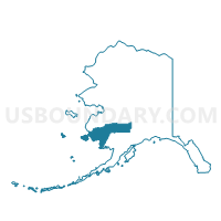
Nightmute Precinct, Bethel Census Area, Alaska
About
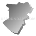
Outline

Summary
| Unique Area Identifier | 523284 |
| Name | Nightmute Precinct |
| County | Bethel Census Area |
| State | Alaska |
| Area (square miles) | 576.60 |
| Land Area (square miles) | 488.27 |
| Water Area (square miles) | 88.33 |
| % of Land Area | 84.68 |
| % of Water Area | 15.32 |
| Latitude of the Internal Point | 60.52371620 |
| Longtitude of the Internal Point | -164.83258170 |
Maps


Graphs
Select a template below for downloading or customizing gragh for Nightmute Precinct, Bethel Census Area, Alaska


Neighbors
Neighoring Voting District (by Name) Neighboring Voting District on the Map
- Chefornak Precinct, Bethel Census Area, AK
- Newtok Precinct, Bethel Census Area, AK
- Toksook Bay Precinct, Bethel Census Area, AK
- Tununak Precinct, Bethel Census Area, AK